NOAA’S GRANT RAWSON (LEFT) AND LUIS POMALES VELÁZQUEZ OF UNIVERSITY OF PUERTO RICO AT MAYAGUEZ GET READY TO DEPLOY A GLIDER. (PHOTO CREDIT: NOAA)
FLORIDA, United States, Sunday July 15, 2018 –The National Oceanic and Atmospheric Administration (NOAA) will soon launch a fleet of 15 unmanned gliders in the Caribbean Sea and tropical Atlantic Ocean this hurricane season to collect important oceanic data that could prove useful to forecasters.
“If you want to improve prediction of how hurricanes gain strength or weaken as they travel over the ocean, it’s critical to take the ocean’s temperature and measure how salty it is,” said Gustavo Goni, an oceanographer at NOAA’s Atlantic Oceanographic and Meteorological Laboratory who is helping lead the glider research. “Not just at the surface, which we measure with satellites, but down into deeper layers of ocean waters.”
NOAA, the United States Integrated Ocean Observing System and university partners will begin deploying the torpedo-shaped, remotely-operated, battery-powered gliders from vessels off Puerto Rico and the US Virgin Islands in mid-July. Ten of the gliders will come from the US Navy, and the others from NOAA.
The gliders will collect the ocean data as they dive down from the surface to a half mile of depth and then regularly resurface several times a day, even during hurricane conditions, to transmit information by satellite to the Global Telecommunications Center used by NOAA’s National Weather Service.
Glider data, as well as data from other ocean observing systems showing lower concentrations of salt in surface seawater, can be a clue that this lighter water may form a warm cap that prevents cool water from welling up to the surface. This warm cap can then fuel a hurricane’s strength.
Glider data also helps scientists better predict if the cooler water lying just below the warm surface waters is likely to rise and mix with the surface waters and weaken hurricane strength.
An analysis by NOAA and university scientists found gliders provided key ocean information to a NOAA experimental forecast model in 2014 that allowed scientists to significantly improve wind intensity predictions for Category-4 Hurricane Gonzalo.
Since 2014, NOAA has launched two to four gliders each hurricane season in this same region. The Navy collaboration will more than triple the number of gliders, which greatly increases the odds that gliders will be close enough to more tropical storms to provide key data for weather forecasts.
Related Articles

Her Ladyship the Honourable Madam Margaret Price Findlay was appointed the 14th Chief Justice of the Eastern Caribbean Supreme Court
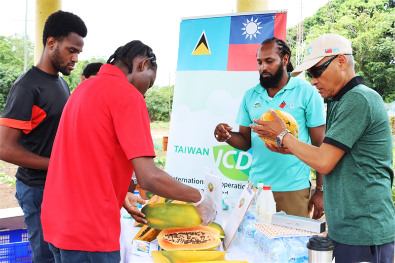
TTM shares best practices in Papaya cultivation

Minister Emma Hippolyte elected to executive committee of OAS Inter-American Commission of Women
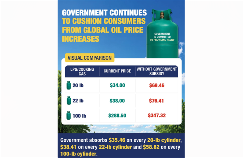
Oil prices increase despite continued Government Fuel and LPG subsidies
Real Estate